The
Old Town of Corfu, on the Island of Corfu off the
western coasts of Albania and Greece, is located in a strategic position
at the entrance of the Adriatic Sea, and has its roots in the 8th century
BC. The three forts of the town, designed by renowned Venetian engineers,
were used for four centuries to defend the maritime trading interests of
the Republic of Venice against the Ottoman Empire. In the course of time,
the forts were repaired and partly rebuilt several times, more recently
under the British rule in the 19th century. The mainly neo-classical housing
stock of the Old Town is partly from the Venetian period, partly of later
construction, notably the 19th century. As a fortified Mediterranean port,
Corfu's urban and port ensemble is notable for its high level of integrity
and authenticity.
Description
The island of Corfu (in Greek: Kerkyra) lies in the Adriatic
Sea off the western coast of Greece and Albania. The Old Town of Corfu
lies between two fortresses midway along the island’s eastern coastline.
The Old Citadel and the New Fort form two remarkable monuments in the
urban fabric. To the east, the canal dug by the Venetians has transformed
the rocky promontory on which the Old Citadel was founded into an island
looking down over the tiny harbour of Mandraki. The citadel retains the
imposing Venetian fortifications, restructured by the British, laid out
on three levels on the far side of the canal linked by a footbridge to
the Spianada. A first outer wall leads to the frontal fortification,
consisting of two orillon bastions (Martinengo and Savorgnan) and a curtain
through which the main gate enters (around 1550). A stone bridge crosses
a broad ditch along which runs a 19 th century barracks. A second wall
protects the base of the two fortified peaks, and access to it is via
a series of ramps and stairs. A vaulted passage leads to the harbour
of Mandraki which itself also retains a monumental gate, now closed.
Some buildings on various levels, mainly dating from the 19 th century,
have been preserved. These include the former Venetian prisons, raised
in height by the British, four powder magazines, the hospital, which
stretches from one peak to the other, two barracks, and the Church of
St. George in the form of a Doric temple (1840).
The imposing structure of the New Fort dominates the north-western sector
of the Old Town. A pentagonal salient, a half-salient, and the small
fort of Punta Perpetua are connected by a rampart and command the old
harbour.
Long sloping tunnels lead to the British barracks and the two bastions
of the Seven Winds linked by a curtain wall and looking out over the
countryside. These look down on 164.a broad ditch and two bastions preserved
from the second Venetian perimeter wall. The two gates of the New Fort
still exist, as does the church of Panagia Spiliotissa (rebuilt in 1739).
The ring road around the Old Town follows the line of the ancient town
wall, some traces of which remain to the west and south and one gate,
the Spilia Gate, of the original four (Royal Gate, St Nicholas Gate,
Raimonda Gate).
The outlines of the Old Town were determined by lack of space and the
needs of defence. The urban fabric forms a compact core consisting of
ten quarters, differentiated by their form. The quarters which range
over the three low hills (Campielo, Agion Pateron, and Agiou Athanassiou)
are irregular and fragmentary in their make-up, a sure sign of the original
suburbs preserved from the demolition necessary for the construction
of the perimeter wall. They are characterised by a network of radial
streets, small squares, and compact blocks of housing clustered around
the churches. The outskirts of these areas, in transition, and the quarters
built in continuation of the perimeter wall present a more regular framework,
especially those which open out behind the Spianada in a grid of straight
lines running east-west.
The two main streets running east-west and the north-south axis which
once connected the Old Citadel to the four gates of the perimeter wall
follow an ancient outline. This simple traffic system, dictated by strategic
imperatives, contrasts with the secondary alleys (the kantounia,
between 1m and 3m wide) which form a complex network of stairs and vaulted
tunnels running through a series of small squares, of which Kremasti
Square is a typical example.
The restricted space within the perimeter dictated the construction
of multi-storey dwellings ranged indiscriminately in serried ranks along
the streets. Though the Old Town must have numbered many a patrician
dwelling during the Venetian period, only a few of these can be identified
in the present day, such as the houses of the Ricchi and Yallina families
(17 th century). The house fronts of this period are characterised by
regular rows of windows, stone balconies, ground-floor arcades, and a
red and ochre rendering that contrasts with the stone door and window
jambs. Many feature doorways ornamented with sculptures. Some public
buildings from the Venetian period still survive: the door of one of
the grain stores (1592), the pawnbroker’s (1630) that forms part of the
Commissioners’ Palace, part of the Spilia barracks, and the Grimani barracks
to the south of the Spianada.
The trend towards building upwards was accentuated in the 19 th century
when the old buildings were raised to anything up to six storeys or,
in most cases, replaced by new buildings which often occupied more space
than in the past by annexing the courtyards. The wider frontages were
divided into three vertical sections, always with many windows, but tended
to become more uniform, particularly along sections of the main streets,
while remaining sober in their classically inspired ornamentation. Balconies
on every floor created a sense of movement and variety in the facades.
Spianada, the esplanade which divides the town from the Old Citadel,
takes up one-third of the surface area of the Old Town. Once the most
populous of the suburbs in the 16 th century, it attained its present
size in the 17 th century for military reasons and is still bordered
by 18 th century barracks. In the late 18 th and early 19 th centuries
it became an architectural showcase dedicated to leisure activities and
civil functions. The French embellished it by constructing arcade-fronted
buildings, the Liston, to the west and planting trees. Under the British
it became a monumental open space with the Neo-Classical Palace of St
Michael and St George (1819-23), once the residence of the Commissioners,
to the north and to the south the circular Ionic temple dedicated to
Maitland: both are the work of George Whitmore (1775-1862).
At the centre of the Old Town stand two large squares, each leading
off one of the two main streets. On Dimarchion Square, once the social
and cultural centre of the Venetian town, which lies on the slopes of
the hill of Agiou Athanassiou, stand the 18 th century Cathedral of St
James, the former residence of the Latin Archbishop (rebuilt in 1754),
and the Loggia Nobilei (1663-69), converted into a theatre in
1720 and home of the Town Hall since the early 20 th century.
On Heroon Square stand the churches of St John (pre-16 th century) and Phaneromeni,
a basilica with three aisles dating from the early 18 th century and
altered in 1832 by Corfiot architect Ioannis Chronis, who designed many
public buildings in the Neo-Classical style for the Old Town, including
the Ionian Bank which stands on the same square, the home of Ioannis
Kapodistrias, the first Greek governor, and the Ionian Parliament (1854,
then restored after the bombings in 1943). To the north of this square
stands the Church of St Spyridon (1589-94, altered in 1670), which houses
the relics of the patron saint of the town and the island. Although the
Orthodox faith was upheld during the centuries of foreign occupation,
contact with the Latin West also influenced the religious architecture
of the Old Town, which shows a strong Byzantine tradition. The example
of the single-aisled church, often with a low exterior narthex running
around the exterior, is much more common than the three-aisled basilica,
although both reflect the repertoires of the Renaissance and the Baroque
style. The simplicity of the facades offers a remarkable contrast to
the elaborate interior decoration. Many ancient churches were enlarged
and renovated in the 18 th century.
History and development
Corfu, the first of the Ionian Islands encountered at the entrance to
the Adriatic, was annexed to Greece by a group of Eretrians (775-750
BCE). In 734 BCE the Corinthians founded a colony known as Kerkyra to
the south of where the Old Town now stands. The town became a trading
post on the way to Sicily and founded further colonies in Illyria and
Epirus. The coast of Epirus and Corfu itself came under the sway of the
Roman Republic (229 BCE) and served as the jumping-off point for Rome’s
expansion into the east. In the reign of Caligula two disciples of the
Apostle Paul, St Jason, Bishop of Iconium, and Sosipater, Bishop of Tarsus,
introduced Christianity to the island. Corfu fell to the lot of the Eastern
Empire at the time of the division in 336 and entered a long period of
unsettled fortunes, beginning with the invasion of the Goths (551).
165.The population gradually abandoned the old town and moved to the
peninsula surmounted by two peaks (the korifi) where the ancient
citadel now stands. The Venetians, who were beginning to play a more
decisive role in the southern Adriatic, came to the aid of a failing
Byzantium, thereby conveniently defending their own trade with Constantinople
against the Norman prince Robert Guiscard. Corfu was taken by the Normans
in 1081 and returned to the Byzantine Empire in 1084.
Following the Fourth Crusade and the sack of Constantinople by the Crusaders
in 1204, the Byzantine Empire was broken up and, in return for their
military support, the Venetians obtained all the naval bases they needed
to control the Aegean and the Ionian Seas, including Corfu, which they
occupied briefly from 1204 to 1214. For the next half-century, the island
fell under the sway of the Despots of Epirus (1214-67) and then that
of the Angevins of Naples (1267-1368), who used it to further their policies
against both the Byzantine Empire now re-established in Constantinople
and the Republic of Venice.
The tiny medieval town grew up between the two fortified peaks, the
Byzantine Castel da Mare and the Angevin Castel di Terra,
in the shelter of a defensive wall fortified with towers. Writings from
the first half of the 13 th century tell of a separation of administrative
and religious powers between the inhabitants of the citadel and those
of the outlying parts of the town occupying what is now the Spianada.
In order to assert its naval and commercial power in the Southern Adriatic,
the Republic of Venice took advantage of the internal conflicts raging
in the Kingdom of Naples to take control of Corfu (1386-1797). Alongside
Negropont (Chalcis), Crete, and Modon (Methoni), it would form one of
the bases from which to counter the Ottoman maritime offensive and serve
as a revictualling station for ships en route to Romania and the Black
Sea.
The ongoing work on defining, improving, and expanding the medieval
fortified perimeter reflects the economic and strategic role of Corfu
during the four centuries of Venetian occupation. In the early 15 th
century activity concentrated on the medieval town, with the development
of harbour facilities (docks, quays and arsenals) and continued with
the renovation of the defence works. Earlyin the following century a
canal was dug, cutting off the medieval town from its suburbs. Following
the siege of the town by the Turks in 1537 and the burning of the suburbs,
a new programme of works was launched to isolate the citadel further
and strengthen its defences. The strip of land (now the Spianada) cleared
in 1516 was widened by demolishing houses facing the citadel walls, two
new bastions were raised on the banks of the canal, the elevation of
the perimeter walls was lowered, and the two castelli were replaced
by new structures. The work, based on plans drawn by Veronese architect
Michele Sanmicheli (1487-1559), were completed in 1558, bringing the
town’s defences up to date with the rapid progress made in artillery
in recent decades.
Yet another siege by the Turks in 1571 decided theVenetians to embark
on a vast project covering themedieval town, its suburbs, the harbour,
and all themilitary buildings (1576-88). Ferrante Vitelli, architect
to the Duke of Savoy, sited a fort (the New Fort) on the low hill of
St Mark to the west of the old town to command the surrounding land and
at sea, and also the 24 suburbs enclosed by a ditched wall with bastions
and four gates.
More buildings, both military and civil, were erected and the 15th century
Mandraki harbour was restructured and enlarged. At the same time, the
medieval town was converted to more specifically military uses (the cathedral
was transferred to the new town in the 17 th century) to become the Old
Citadel.
Between 1669 and 1682 the system of defences was further strengthened
to the west by a second wall, the work of military engineer Filippo Vernada.
In 1714 the Turks sought to reconquer Morea (the Peloponnese) but Venetian
resistance hardened when the Turkish forces headed towards Corfu. The
support of Christian naval fleets and an Austrian victory in Hungary
in 1716 helped to save the town. The commander of the Venetian forces
on Corfu, Giovanni Maria von Schulenburg, was inspired by the designs
of Filippo Vernada to put the final touches to this great fortified ensemble.
The outer western defences were reinforced by a complex system of outworks
on the heights of two mountains, Abraham and Salvatore, and on the intermediate
fort of San Rocco (1717-30).
The treaty of Campo Formio (1797) marked the end of the Republic of
Venice and saw Corfu come under French control (1797-99) until France
withdrew before the Russian-Turkish alliance that founded the State of
the Ionian Islands, of which Corfu would become the capital (1799-1807).
The redrawing of territorial boundaries in Europe after the fall of Napoleon
made Corfu, after a brief interlude of renewed French control (1807-14),
a British protectorate for the next half-century (1814-64).
As the capital of the United States of the Ionian Islands, Corfu lost
its strategic importance. Under the governance of the British High Commissioner
Sir Thomas Maitland (1816-24), development activity concentrated on the
Spianada; his successor, Sir Frederic Adam (1824-32), turned his attention
towards public works (building an aqueduct, restructuring the Old Citadel
and adding new military buildings at the expense of the Venetian buildings,
reconstruction and raising of the town’s dwellings) and the reorganisation
of the educational system (the new Ionian Academy was opened in 1824),
contributing to the upsurge in intellectual interests sparked during
the French occupation. At the same time, the British began demolishing
the outer fortifications on the western edge of the town and planning
residential areas outside the defensive walls.
In 1864 the island was attached to the Kingdom of the Hellenes. The
fortresses were disarmed and several sections of the perimeter wall and
the defences weregradually demolished. The island became a favoured holiday
destination for the aristocracy of Europe. The Old Town was badly damaged
by bombing in 1943. Added to the loss of life was the destruction of
many houses and public buildings (the Ionian Parliament, the theatre,
and the library), fourteen churches, and a number of buildings in the
Old Citadel. In recent decades the gradual growth of the new town has
accelerated with the expansion of tourism.
OUTSTANDING UNIVERSAL VALUE, INTEGRITY AND AUTHENTICITY
Integrity and Authenticity
Integrity
The Old Town of Corfu is a fortified Mediterranean harbour retaining
traces of Venetian occupation, including the Old Citadel and the New
Fort, but primarily of the British period.
The strict legal measures enacted after World War II, and the listing
of the town for protection as a cultural monument in 1967 have provided
the basis for the control of changes and the possibility to retain the
integrity of the town. During the British period, three forts were preserved:
the Old Fortress, the New Fortress and the small island of Vidos. The
plan provided for the demolition of all the western forts. The British
did demolish the south-west side in 1937 and fort of Sotiros in 1938
to give space for prisons. In the old and new fortresses, the British
intervention related to internal restructuring and some new additions.
The overall form of the fortifications has been retained. Nevertheless,
like most fortifications, Corfu has faced many severe military attacks,
causing destruction, demolition and rebuilding. The interventions of
the 19 th century and the rebuilding after the World War II have in fact
reduced the historic fabric of the property. Only a relatively small
part of the structures actually dates from the Venetian period.
Authenticity
Corfu developed from a small Byzantine town along the lines of a western
urban model, which can be seen on all cultural levels and displayed in
the town’s structure and form. The Old Town of Corfu today occupies the
same area as the ancient town whose overall design it still reflects,
with the two fortifications, the open space of the Spianada, the compact
urban core with its different quarters and the streets. This urban fabric
has been shaped by centuries of demolition and reconstruction dictated
by military needs. In the 19 th century the British were the first to
begin dismantling the complex Venetian defence system, the scale of which
is amply illustrated by the many maps still extant. The British example
was followed by the Greek government after 1864.
About 70% of the pre-20 th century buildings date from the British period.
There were no large openings made in Corfu as was the case in many other
fortifications. Some of the dwellings have undergone further modifications
in the 20 th century, such as the addition of an extra floor.
World War II bombing destroyed some houses and buildings in the Old
Town, particularly in the western section, where whole blocks were destroyed.
The buildings thus lost were in part replaced by new constructions in
the 1960s and 1970s.
These interventions represent a particular juncture in history and express
the aesthetic attitudes of their time, clearly distinguished from previous
buildings. The existence of rich records on the old form of the town
has ensured full documentation in the case of interventions to existing
buildings. The fortifications of Corfu and the historic urban areas have
been subject to various armed conflicts and consequent destruction. The
present form of the ensemble results from the works in the 19 th and
20 th centuries, even though based on the overall design of previous
phases, particularly in the Venetian period. ICOMOS considers that the
fortified ensemble of Corfu is authentic, despite the many structural
alterations resulting from its major strategic importance as a military
position. It has been actively involved in many conflicts which took
place at the point of contact between the West and the Mediterranean
East from the 15 th to the 20 th centuries. It has been rebuilt several
times, and altered to allow for developments in weapons of attack and
principles of defence, successively by the Venetians and by the British.
The integrity of the fortified ensemble, in its current state of conservation,
is satisfactory in terms of expressing its outstanding value. ICOMOS
considers that the urban site of Corfu is representative of an urban
history which is closely associated with the structure of forts and ramparts.
ICOMOS considers however that the authenticity and integrity of the urban
fabric are primarily those of a neo-classical town.
In conclusion, ICOMOS considers that the authenticity and integrity
of the fortified ensemble of Corfu enable the expression of its outstanding
value.
Comparative analysis
The comparative analysis in the 2006 nomination document refers to the
following Mediterranean fortified cities: Rhodes, Valletta, Dubrovnik,
Trogir, and Heraklion.
In the supplementary information provided by the State Party, the comparison
has been extended to several other port towns in Italy, the Near East
and the Dalmatian coast.
Corfu is distinguished partly due to archaeological evidence of history
from the 8 th century BC and from the Byzantine period.
It is argued by the State Party that Corfu is characterised due to its
European influences and for its identity resulting from its role as a
crossroads of civilisations. The fortifications of the Venetian period,
designed by architects Sanmicheli, gave Corfu a major role as one of
the strategic military bases of Venice at the entrance to the Adriatic
Sea. It is also one of the few areas that avoided Ottoman occupation
keeping its western character.
There are a number of important fortifications in the eastern Mediterranean
region. Of these, Valletta and Dubrovnik are certainly the most impressive.
The maritime republic of Venice established its reign through a series
of fortifications along the Dalmatian coast, and Corfu was one of these.
The Ottoman Empire ruled in the inland of the Balkans and in the eastern
part of the Mediterranean, including the old town of Rhodes and the town
of Heraklion on the island of Crete. From the mid 14 th century Dubrovnik
became an autonomous republic and a rival to Venice. Valletta instead
was ruled by the Knights of Malta and remained the most important fortified
port in this part of the Mediterranean until the 20 th century.
ICOMOS considers that Corfu certainly had an important strategic position
at the entrance to the Adriatic Sea. For this reason it also had to face
the many attacks by the Ottomans. Historically, the property has its
origins in antiquity, but architecturally the fortification represents
a typical Renaissance fort, which was rebuilt several times.
The housing stock is in neo-classical style, but without special architectural
features for which it could be distinguished.
ICOMOS considers that the comparative study that accompanies the new
dossier is satisfactory, and that it enables a suitable assessment of
the value of the property.
Justification of the Outstanding Universal Value
The State Party considers that Corfu has an Outstanding Universal Value
for the following:
The Old Town of Corfu, internationally renowned, is a unique cultural
entity of a high aesthetic value: the aesthetic value is recognised in
the structure and form of the once-walled town, as well as in its arts,
letters and social life. The Old Town developed diachronically, through
the osmosis of features of the two worlds of the Mediterranean, the East
and the West. It has been preserved, alive and substantially unaltered,
until the present day.
The defence system and the urban fabric were designed and developed
during the Venetian period, from the 15 th to the 18 th centuries, and
then by the British Empire during the 19 th century.
The importance of Corfu’s fortifications for the history of defensive
architecture is huge. From both the technical and aesthetic point of
view they constitute one of the most glorious examples preserved, not
only in Greece, but across the Eastern Mediterranean more widely. At
various occasions, Corfu had to defend the Venetian maritime empire against
the Ottoman army.
Neo-classical in its architecture, the old town bears witness to the
duration of European architectural and cultural influence in the Balkans,
which were mainly dominated by the Ottoman empire. Corfu is also important
for studying the development of urban multi-storey buildings, since it
is the first Greek city in which the idea of horizontal ownership appeared.
The composite character of the town that resulted from its history and
the ability to assimilate differences without conflict led to the development
of a particular cosmopolitan atmosphere with intense European symbolism.
http://whc.unesco.org/en/list/978
 |
 |
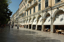
| The Francs created Liston, reminiscent of Rue Rivoli in Paris |
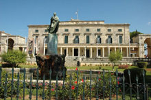
The Palace of Michail and Georgiou, house of the English Commissioner, bearing neoclassical elements. |
| |
 |
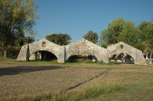 |
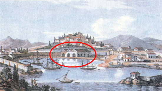
| In the Gulf of Gouvia, 9 kilometres north of the city of Corfu, the Venetians had built their dockyards (in red circle). |
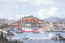
The dockyards as they are today. |
| |